Greenland melted recently, shows high risk of sea level rise today
 (Download Image)
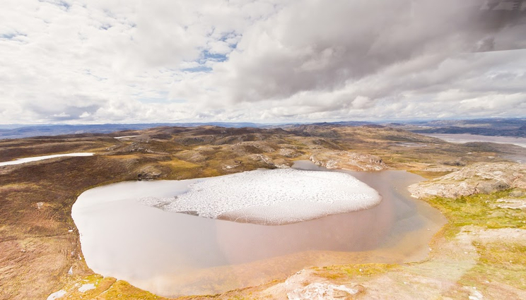
A large portion of Greenland melted about 416,000 years ago — perhaps a bit like the small melt pond shown in this modern Greenland landscape — and became ice-free tundra or a boreal forest. Photo by Joshua Brown/University of Vermont.
A large portion of Greenland was an ice-free tundra landscape — perhaps covered by trees and roaming wooly mammoths — in the recent geologic past (about 416,000 years ago), according to a new study in the journal Science.
The results shed light on the stability of the Greenland ice sheet, which was long assumed to have been frozen continuously over the last two and a half million years. Instead, moderate warming (mean global temperatures of 1 to 1.5°C above pre-industrial values) led to significant melting consisting of at least 20% of the total Greenland ice sheet volume.
The melting of Greenland caused at least five feet of sea level rise, despite atmospheric levels of heat-trapping carbon dioxide being far lower than today (280 vs. 420 ppm). This indicates that the ice sheet on Greenland may be more sensitive to human-caused climate change than previously understood and will be vulnerable to irreversible, rapid melting in coming centuries.
The scientists from Lawrence Livermore National Laboratory (LLNL), the University of Vermont (UVM), Utah State University and 13 other institutions used sediment from a long-lost ice core, collected at a secret U.S. Army base in the 1960s, to make the discovery. They applied advanced luminescence and isotope techniques to provide direct evidence of the timing and duration of the ice-free period.
A green land
During the Cold War, a secret U.S. Army mission at Camp Century in northwestern Greenland, drilled down through 4,560 feet (1,370 meters) of ice on the frozen island — and then kept drilling to pull out a 12-foot-long tube of soil and rock from below the ice. Then this icy sediment was lost in a freezer for decades. It was accidentally rediscovered in 2017 and shown to hold not just sediment but also leaves and moss, remnants of an ice-free landscape and perhaps a boreal forest.
But how long ago were those plants growing, where today stands an ice sheet two miles thick and three times the size of Texas?
An international team of scientists was amazed to discover that Greenland was a green land only 416,000 years ago (with an error margin of about 38,000 years).
Their new study was published in the journal Science on July 21, 2023.
Bulletproof evidence
Until recently, geologists believed that Greenland was a fortress of ice, mostly unmelted for millions of years. But, two years ago, using the rediscovered Camp Century ice core, this team of scientists showed that it likely melted less than one million years ago. Other scientists, working in central Greenland, gathered data showing the ice there melted at least once in the last 1.1 million years, but until this study, no one knew exactly when the ice was gone.
Now, using advanced luminescence technology and rare isotope analyses conducted by Lawrence Livermore scientist Alan Hidy, the team has created a starker picture: large portions of Greenland’s ice sheet melted much more recently than a million years ago. The new study presents direct evidence that sediment just beneath the ice sheet was deposited by flowing water in an ice-free environment during a moderate warming period called Marine Isotope Stage 11, lasting 30,000 years, between 424,000 to 374,000 years ago. This melting caused at least five feet (1.4 meters) of sea level rise around the globe.
Understanding Greenland’s past is critical for predicting how its giant ice sheet will respond to climate warming in the future and how quickly it will melt. Since about 23 feet (7 meters) of sea-level rise is tied up in Greenland’s ice, every coastal region in the world is at risk. The new study provides strong and precise evidence that Greenland is more sensitive to climate change than previously understood — and at grave risk of irreversibly melting off.
“Greenland’s past, preserved in 12 feet [3.4 meters] of frozen soil, suggests a warm, wet and largely ice-free future for planet Earth,” said University of Vermont scientist Paul Bierman, who co-led the new study, “unless we can dramatically lower the concentration of carbon dioxide in the atmosphere.”
Into the light
The team’s new study, combined with their earlier work, is causing a major and worrisome rethinking of the history of Greenland’s ice sheet. “It had always [been] assumed that the Greenland ice sheet formed about two and a half million years ago — and has just been there this whole time and that it’s very stable,” says Tammy Rittenour, a scientist at Utah State University and co-author on the new study. “Maybe the edges melted, or with more snowfall it got a bit fatter — but it doesn’t go away and it doesn’t dramatically melt back. But this paper shows that it did.”
At Rittenour’s lab, sediment from the Camp Century core was examined for what is called a “luminescence signal.” As bits of rock and sand are transported by wind or water, they can be exposed to sunlight — which, basically, zeros out any previous luminescence signal — and then re-buried under rock or ice. In the darkness, over time, minerals of quartz and feldspar in the sediment accumulate freed electrons in their crystals. In a specialized dark room, Rittenour’s team took pieces of the ice core sediment and exposed them to blue-green or infrared light, releasing the trapped electrons. With some advanced tools and measures, and many repeated tests, the number of released electrons forms a kind of clock, revealing with precision the last time these sediments were exposed to the sun. “And the only way to do that at Camp Century is to remove a mile of ice,” said Rittenour. “Plus, to have plants, you have to have light.”
These powerful new data were combined with insight from Bierman’s UVM lab. There, scientists studied quartz from the Camp Century core. Inside this quartz, rare isotopes of the elements beryllium and aluminum build up when the ground is exposed to the sky and can be hit by cosmic rays.
Looking at ratios of beryllium and other isotopes gave the scientists a window onto how long rocks at the surface were exposed, as opposed to being buried under layers of ice. This data helped the scientists show that, 400,000 years ago, the Camp Century sediment was exposed to the sky less than 16,000 years before it was deposited under the ice, narrowing down the time window when that portion of Greenland must have been ice-free.
The ultra-trace beryllium isotope measurements made during this study are only possible at LLNL’s Center for Accelerator Mass Spectrometry facility. There was minimal core material available for the analysis, and concentrations were in the tens of thousands of atoms per gram of quartz. LLNL’s Alan Hidy performed the analysis of the isotope data and helped develop the exposure-burial model.
Under ice
Camp Century was a military base hidden in tunnels under the Greenland ice sheet in the 1960s. As cover, the Army claimed the camp was an Arctic science station.
Once the military left the site, the science team completed first-of-its-kind research, including drilling a nearly mile-deep ice core. The Camp Century scientists were focused on the ice itself — part of an effort to understand Earth’s past ice ages and warm periods known as interglacials. They took little interest in the 12 feet (3.4 meters) of sediment gathered from beneath their ice core. Then, in a bizarre story, the ice core was moved in the 1970s from a military freezer to the University at Buffalo and then to another freezer in Denmark in the 1990s. There it was lost for decades until it was found again when the cores were being moved to a new freezer.
Sea level
Camp Century is 138 miles inland and only 800 miles from the North Pole; the new Science study shows that the region entirely melted and was covered with vegetation during Marine Isotope Stage 11, a long interglacial with temperatures similar to or slightly warmer than today. With this information, the team’s models show that during that period, the ice sheet melted enough to cause at least five feet (1.4 meters), and perhaps as much as 20 feet (6 meters), of sea-level rise. Hidy helped with the interpretation and development of this model.
The research, supported by the U.S. National Science Foundation, lines up with findings from two other ice cores collected in 1990s from the center of Greenland. Sediment from these cores also suggest that the giant ice sheet melted in the recent geologic past. The combination of these earlier cores with the new insight from Camp Century reveal the fragile nature of the entire Greenland ice sheet in the past (at 280 parts per million [ppm] of atmospheric CO2 or less) and today (422ppm and rising).
“If we melt just portions of the Greenland ice sheet, the sea level rises dramatically,” said Utah’s Tammy Rittenour. “Forward modeling the rates of melt and the response to high carbon dioxide, we are looking at meters of sea level rise, probably tens of meters. And then look at the elevation of New York City, Boston, Miami, Amsterdam. Look at Bangladesh, India, and Africa — most global population centers are near sea level.”
“Four-hundred-thousand years ago there were no cities on the coast,” said Bierman, “and now there are cities on the coast.”
Basil Waugh of the University of Vermont contributed to this article.
Contact
 Anne M. Stark
[email protected]
(925) 422-9799
Related Links
ScienceTags
Earth and Atmospheric SciencePhysical and Life Sciences
Atmospheric, Earth, and Energy
Featured Articles