'Live models' offer dynamic view of subsurface
It started about five years ago when the Lab was tasked with helping to maintain an underground test readiness program in the event that the resumption of nuclear weapons testing became necessary at the Nevada Test Site.
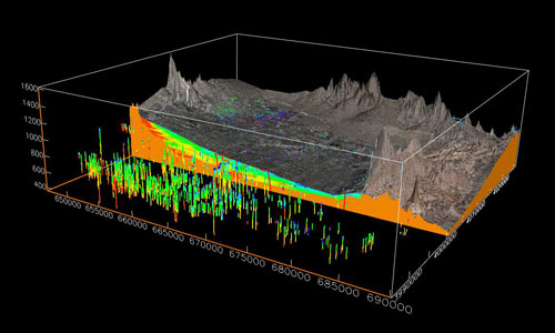
Jeff Wagoner of the Atmospheric, Earth and Energy Division within the Physical and Life Sciences Directorate created three-dimensional (3D) geologic models to show what areas in the Las Vegas basin were most vulnerable to ground motion.
With the expansion of Las Vegas and surrounding suburbs during the last 17 years since underground testing at NTS ceased in 1992, the area had changed quite a bit.
"We had to look at the impacts if underground tests were renewed," Wagoner said. "We hadn't done that since underground tests were banned in 1992 and Las Vegas and its outer reaches had grown considerably."
Using a software code called Earthvision, Wagoner created a geological model of the Las Vegas basin subsurface that helps seismologists and engineers estimate potential ground shaking in the area. This technology can help in predicting the dangers of structural damage in the event of resumed underground nuclear testing, as well as evaluating the earthquake hazards in the area.
Wagoner found the basin contained clay, sand, silt, gravel and caliche (a type of soil formed by calcite deposited beneath the surface in dry environments that can be as hard as concrete). Using data from boreholes, he is able to create a realistic 3D model of these sediments and their vertical and lateral variability in the basin.
"This kind of detailed lithologic model of the Las Vegas basin had never been done before," Wagoner said. "This technology can be applied to any basin. It's simply another tool that the seismologists and engineers can use to determine seismic risk."
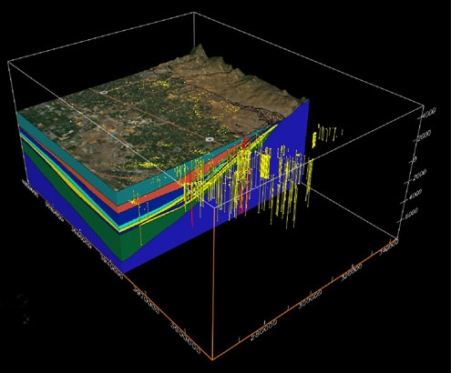
And now the very same code is being used to create 3D models in the southern San Joaquin basin where carbon dioxide (CO 2 ) will be stored underground.
The Westcarb Kimberlina Demonstration Project is planning to inject 1 million tons of CO 2 over four years into a deep geologic formation below a zero-emission power plant near Kimberlina, Calif., just north of Bakersfield. The Clean Energy Systems (CES) power plant will produce a relatively pure stream of CO 2 . Instead of emitting this by-product into the atmosphere, the CO 2 will be compressed and injected into one of a number of potential storage formations below the plant, where it will be sequestered.
"But in order to predict where the CO 2 will migrate, we need to understand the subsurface geology below and surrounding the plant," Wagoner said.
Wagoner has constructed a regional 3D geologic model centered on the Kimberlina power plant with a depth range from the topographic surface to more than 9,000 meters below sea level. He constructs the models using surface maps, borehole data and geophysical surveys. Wagoner's models are "living models," meaning that they are revised as more data becomes available from new boreholes or geophysical surveys.
"This provides us a framework of what the subsurface geology looks like," Wagoner said. "You need to understand the geology before you start injecting CO 2 underground, because this allows you to predict where it will migrate in the subsurface."